
Our Island’s Glacial History
The expanse of time and the power of the Earth
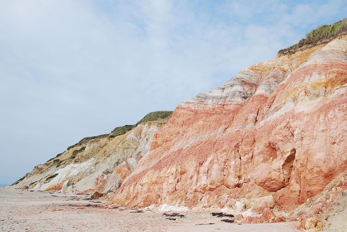
The expanse of time and the power of Earth’s geologic forces are revealed in the imposing but beautiful clay cliffs of Aquinnah. The bright colors and changing textures of the layered strata are the result of glaciers advancing and retreating– depositing, deforming, and dislocating over the eons.
The granitic bedrock “basement” found 800 – 1,000 feet beneath the surface of this part of the Vineyard was formed some 200 to 570 million years ago. Atop that lie glacial deposits of various ages, and from various origins. What makes the cliffs truly remarkable is that so many geological epochs are clearly evidenced at the surface:
- Cretaceous outcroppings dating to about 95 million years old, consisting of red clays and white clays, similar in age to the white Cliffs of Dover.
- Black lignite deposits from about 90 million years in age, consisting of old plant material deposited when areas beyond the current shoreline were above water.
- Miocene Greensands strata containing a diversity of fossils dating to about 10 – 14 million years ago.
- The Aquinnah Conglomerate, consisting of more recent glacial debris, dating to about 100,000 years old. This is a fairly thin layer near the top of the Cliffs where ground quartz pebbles (as well as camel and other bones) have been found.
The Gay Head Cliffs present in vivid colors the effects of plate tectonics over vast periods of time. It is a geological history of the coastal plain, formed as a result of the erosion of the once great mountains of the eastern seaboard that were thrust upward when the continents of Africa and North America collided. The subsequent continental retreat and spreading created the Atlantic Ocean and brought an end to the eastern mountain building epoch.
Martha’s Vineyard was under water during many of these geological periods. However, some 23-35 million years ago it was above water, with evidence of erosion processes at work. Layers from this period include fossils of plants, mollusks, and other material deposited in ancient streams, embankments, and lakes.
The Cretaceous Period is broadly described as between 60 and 144 million years ago. The so-called “thrust beds” at the Aquinnah cliffs describe a situation where some upper layers are older, mostly Cretaceous material that was “thrusted over” younger layers.
The Greensand beds are much younger, as recent as 5 million years old. They contain fossils of fish, whales, rhinoceros, and mastodon, as well as fossilized coral and “gizzard stones” called gastroliths from seals and other sea mammals. Based on fossilized pollen spores, it appears the climate at this time was subtropical.
But by about 1.5 million years ago, the climate began cooling, becoming temperate: pre-glaciation, pre-Pleistocene. This cooling was episodic, with cooling and glacial formation driven by Earth’s orbital changes and polar rotation changes.
This most recent Ice Age impacting eastern North America is known as the Wisconsin Glacial Stage, when part of the vast Laurentide Ice Sheet spread its way south from the Arctic. That southward advance of glaciers began about 100,000 years ago, coming to a halt around 21,000 years ago in the vicinity of Martha’s Vineyard. About 3,000 years later, a warming trend triggered a slow glacial retreat northward. During that period, the sea level around the Vineyard was about 300 feet below today’s, revealing a vast plain stretching outward to the continental shelf.
The glacial advance and retreat were uneven, mirroring the shape of the bedrock beneath, depositing “drift” in its wake. Two distinct glacial lobes have been described, the Buzzards Bay Lobe to the west, and the Cape Cod Lobe to the east.
Today, we are living in an interglacial stage, the Holocene Epoch. The anticipated timeline for our next glacial stage is unknown, a prediction made even more challenging by anthropogenic global warming – where humanity has condensed the timescale from geologic to that of our own lives – and whatever other grand human impacts may yet follow.
Walking Through History: scenes from a 2013 Winter Walk at the cliffs
Below, excerpts from Woodward and Wigglesworth, 1934: Geography and Geology of the Region Including Cape Cod, the Elizabeth Islands, Nantucket, Martha’s Vineyard, No Mans Land and Block Island
The largest exposures of beds of Cretaceous clay in the Gay Head cliffs may be seen in a section over a mile long. Here may be found the whole series so far as it is known, beds of lignite, upon which lie the beds of clay and white kaolin sand. The section has been gullied considerably and presents much the same form as a cliff in a badland region.
The colors of the beds here are strikingly brilliant. Beds of Cretaceous clay may be seen in a section over a mile long. Upon the Upper Cretaceous clay lie the Miocene greensand and some Pliocene sand, which is in turn overlain by Pleistocene deposits.
The thickness of the Cretaceous beds exposed here is exceedingly difficult to estimate on account of complicated folding and overthrusting, but it probably nowhere exceeds 100 feet.